 Active Metrics
Maps & Offline Maps
The live map during a workout
Outdoor workouts include a map page (one of the swipeable pages — see Data Screens). It shows:
- Your breadcrumb trail — the path you’ve covered so far.
- Your planned route, if you selected one, drawn as a separate line (it dims once navigation takes over, so your actual track stands out).
- Turn markers and, if you go off course, a dashed red line back to the route — see Routes & Navigation.
- A metrics strip below the map, so you don’t lose your numbers while glancing at it.
The map is locked by default: it follows your position and the Digital Crown keeps paging between screens. Tap the lock button to unlock — then you can pan by dragging and zoom with the crown. It re-locks itself after a few seconds of inactivity and snaps back to following you.
Map styles
Two basemap styles, picked on the watch under Settings → Map → Style:
- Standard — Apple’s map data. Familiar look.
- Trail (beta) — Active Metrics’ own vector map, tuned for glanceability outdoors: a dark high-contrast basemap with trail and street labels, heading-up rotation so the direction you’re moving points up, and a range ring ahead of you showing distance (and time, at your current pace) to its edge.
The Trail style and the app’s own offline downloads are Active Metrics Pro features; the Standard style is free. See the FAQ.
Both styles work offline — they just download differently. The Standard style uses Apple’s offline maps, downloaded through the Apple Maps app (next section). The Trail style uses the app’s own offline areas (the sections after).
Offline maps for the Standard (Apple) style
The Standard style draws from Apple’s map data, so its offline coverage comes from Apple’s own offline maps feature rather than the app’s downloads:
- On your iPhone, open the Apple Maps app, tap your picture or initials next to the search field, then tap Offline Maps → Download New Map. Frame the area and download it.
- In that same Offline Maps screen, turn on Sync with Apple Watch so the downloaded maps are available on the watch even when your iPhone isn’t nearby. (With the phone in Bluetooth range, the watch uses its offline maps automatically.)
Once downloaded, the Standard style in Active Metrics keeps working in that area without a connection — on both the phone and the watch.
Downloading offline areas on your iPhone
On the Plan tab, open Maps → Offline Maps and tap Add Area. Frame the area you want inside the rectangle on the map, name it, and pick a detail level (Overview, Standard, or Detailed — more detail means more tiles). The form shows the tile count and estimated download size before you commit; if the area is too large, zoom in or reduce the detail level.
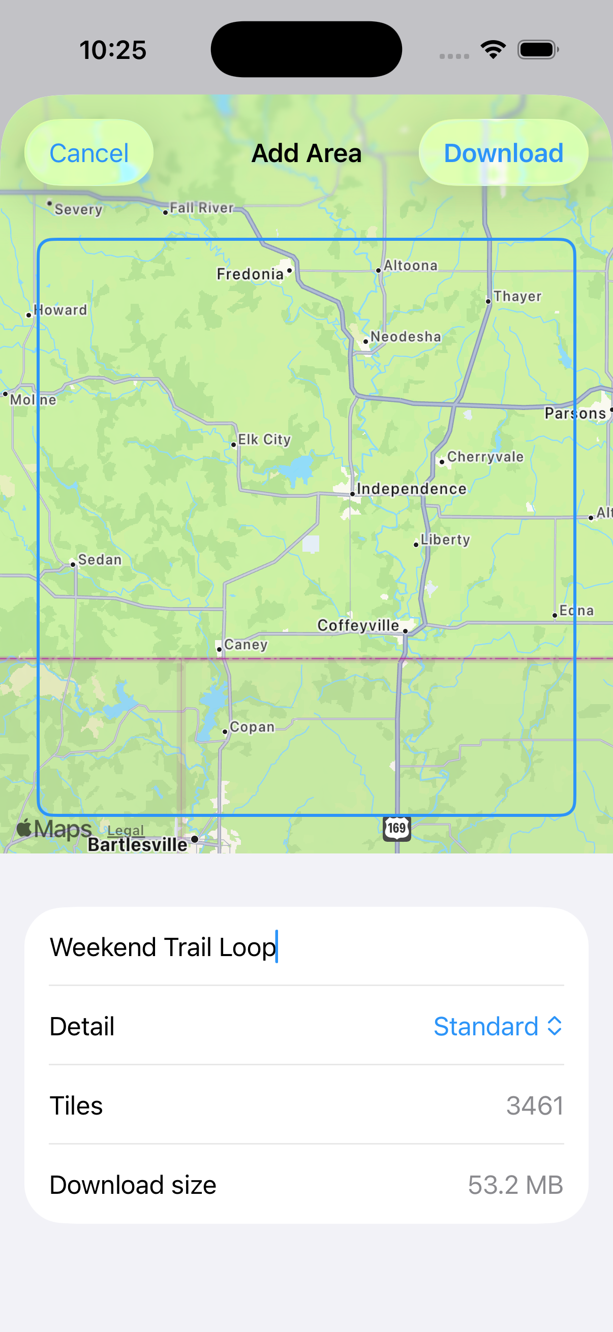
Downloaded areas sync to your watch automatically — the phone sends a small description of the region and the watch downloads its own copy of the tiles directly. Nothing large moves over the watch-phone link.
Downloading straight from the watch
The watch can also download without the phone: Settings → Map → Offline Maps offers two options under Download:
- Nearby — a square around your current location, with a 5, 10, or 20 km radius.
- From a Route — the area covering one of your saved routes, handy before a race or point-to-point run.
Both show the tile count and estimated size before you start. Downloads run one at a time; anything else you queue waits its turn. For a large region, keep the watch awake and on its charger — downloads run in the foreground.
Managing storage
Everything lives in the same Offline Maps screens:
- Sizes — each downloaded region lists its size on disk. Estimates run roughly 15 KB per tile, so a 10 km-radius area typically lands in the tens of megabytes.
- Download over Cellular (watch, off by default) — lets watch-created downloads use cellular. Regions planned on the phone always wait for Wi-Fi on the watch, regardless of this toggle; a queued region shows “Waiting for Wi-Fi” until then.
- Delete — swipe a region to remove it and free its tiles. Tiles shared with another overlapping region are kept.
- Clear Map Cache (watch) — clears tiles picked up during everyday map browsing. Your downloaded regions are untouched.
If a download is interrupted it shows as incomplete — tap it on the watch to retry.
Before you go off-grid
Practical order of operations for a trip somewhere with no signal:
- Download the area (or the route’s corridor) before you leave, on Wi-Fi — an offline area in the app for the Trail style, or an Apple Maps offline map for Standard.
- Wait for the region to show ready on the watch — not just on the phone.
- If you’re navigating, sync the route to the watch too — see Routes & Navigation.
Worth a dry run before you rely on it: download a region, then put the watch in airplane mode and check the map is actually usable before you’re somewhere it matters.
Map tiles not loading at all? Check Troubleshooting or email activemetrics@spearssoftware.com.